Two Models Show Two Different Snow Outcomes for New England
What's going to happen with snow this weekend? Everyone is trying to figure that out, but there are a few different models to look at which could change how much snow we actually get from Saturday night into Sunday night in New England.
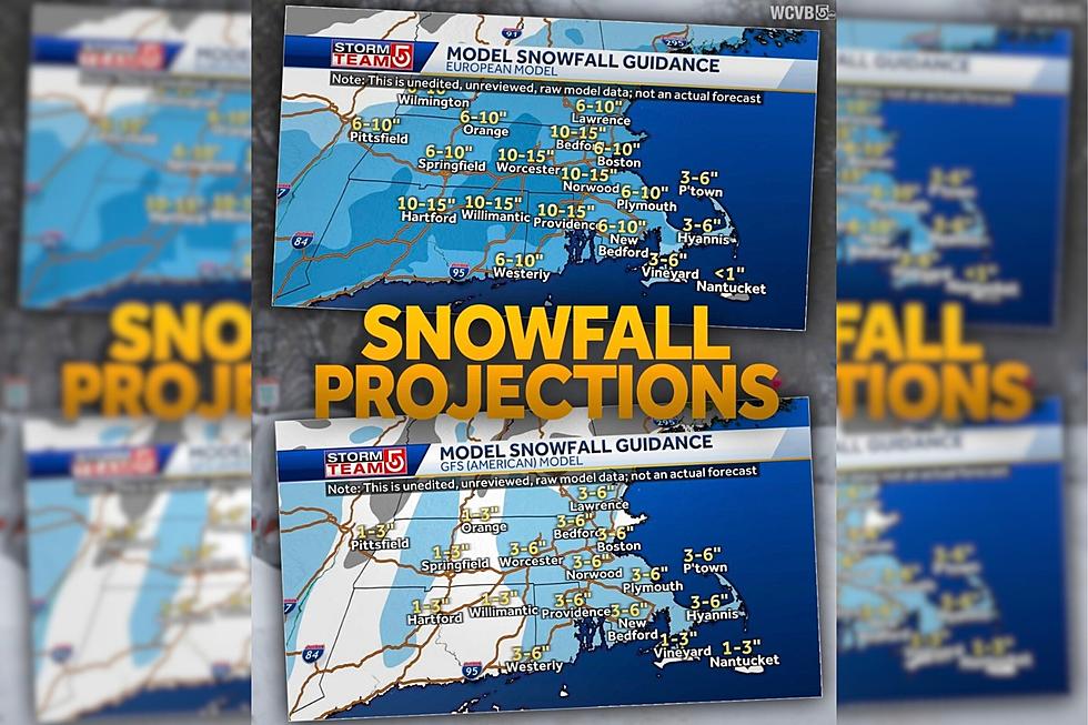
WCVB Meteorologist Mike Wankum uses these models to show how the European and American tracks are watching the same storm but with different snow totals.
Look at the European model in the photo. It looks like most of New England could see 10" to 15" of snow this weekend, but the American model looks like far less, with totals up to 6" in most areas.
Further north in ski country, we could see well over a foot of new snow, which is good news for skiers and ski mountains.
Irina Igumnova
So what's really going to happen? It's New England. It feels like the weather folks always say it's going to be worse than it really is. But then there are the times when they underestimate the strength of a Nor'easter.
These storms aren't called Nor'easters for nothing. They have potential to knock out power for days, and wreak all kinds of havoc to affect our lives. You know how it is in New England. We plow through the winters to get to the beautiful summers.
Get those shovels and plows ready, because either way, we are getting snow...finally. And so it goes.
8 of the Coziest New England Towns to Visit This Winter
Gallery Credit: Megan
24 Things to Do During the New England Winter if You Aren't Into Winter Sports
More From 97.5 WOKQ


